

Never Miss a Beat: Get a snapshot of the issues affecting the IT industry straight to your inbox.
The indispensable Google Maps and its highly addictive cousin, Google Earth, are getting major quality updates thanks to Landsat 8 satellite imagery.
3 Min Read
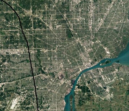
<p align="left">Detroit (Image: Google)</p>

ISS Milestone: 10 Images From 100,000 Orbits
ISS Milestone: 10 Images From 100,000 Orbits (Click image for larger view and slideshow.)
Google has made major upgrades to its popular mapping service Google Maps and its addictive bird's eye view application, Google Earth, giving them fresh imagery from Landsat 8 satellite and new processing techniques for creating even sharper images.
In an effort to create a cloud-free map of the Earth, Google looked at millions of images and took the clearest pixels to stitch together a cloudless and seamless image.
The new imagery is available across all of Google's mapping products. To check it out, users simply open up Google Earth or turn on the satellite layer in Google Maps.
Landsat 8 is an American Earth observation satellite that images the whole planet every 16 days, and captures images with greater detail and truer colors than done previously, at an unprecedented frequency, creating twice as many images as Landsat 7 does every day.
The Landsat 8 satellite, which launched into orbit in 2013, is the newest sensor in the US Geological Survey (USGS) and NASA Landsat Program.
Using the same publicly available Earth Engine APIs employed by scientists worldwide, Google mined data from nearly a petabyte of Landsat imagery -- more than 700 trillion individual pixels -- to choose the best cloud-free pixels.
"To put that in perspective, 700 trillion pixels is 7,000 times more pixels than the estimated number of stars in the Milky Way Galaxy, or 70 times more pixels than the estimated number of galaxies in the universe," Chris Herwig, program manager for Google Earth Engine, wrote in a June 27 blog post announcing the upgrades.
For example, comparing two images of Manhattan in New York City on the company's Google Maps blog, one can see the difference in detail. In the new view of New York City, details like skyscrapers, building shadows, and baseball and softball fields in Central Park show up with a much higher level of clarity and sharpness.
[Read more about Google's Project Bloks.]
"Three years ago we introduced a cloud-free mosaic of the world in Google Earth. Today we're rolling out an even more beautiful and seamless version, with fresh imagery from Landsat 8 satellite and new processing techniques for sharper images than ever before," Herwig wrote.
Landsat has observed the Earth continuously from 1972 to the present day and offers a wealth of information on the changes to the Earth's surface over time. Herwig noted the update to Maps and Earth was made possible in a large part thanks to the program and its commitment to free and accessible open data.
The update also allowed Google to fill in some large diagonal gaps in maps that were affected by a hardware failure on Landsat 7 images captured after 2003.
Not one to be left out of the fun, Google's Street View team, responsible for driving around the world and mapping the world from a human-scaled perspective, has been going on some wild rides of its own as of late, including one to the colorful and exotic Coral Triangle in Asia, home of the richest coral reefs on Earth, and the horrific prison cells of Robben Island, South Africa, where Nelson Mandela spent 18 years in solitary confinement before attaining freedom.
About the Author(s)
You May Also Like
More Insights
Editor's Choice


May 2, 2024
While there are plentiful options in cyber resiliency and business continuity tools and platforms, there isn’t one that can knock out everything from sudden cloud outages to prolonged ransomware attacks in a single punch. What can you do to keep the company on its feet no matter what is thrown at it? Find out in this new virtual event.
Reserve Your Seat Now